Technical Blogs
Enhancing Integrity in ARR Carbon Projects
Beyond static documents and claims, credibility in the carbon market requires an integrated, digital evidence chain to back up removal claims.
As demand for high-quality nature-based carbon credits grows, the technical burden on project developers is increasing. Actors in the carbon market landscape - buyers, regulators, host countries, and ratings agencies, want credible evidence that removals are real, additional, durable, spatially attributable, conservatively quantified, and independently auditable.
This is a measurement and data architecture issue, as opposed to a communication issue. The World Bank’s 2025 MRV note frames the core integrity challenge clearly - carbon markets depend on verifying that claimed greenhouse gas reductions and removals are actually delivered. It identifies dMRV as a practical foundation for scaling carbon market systems, with evaluation criteria around transparency, accuracy, cost-effectiveness, scalability, and accessibility. This is echoed by ICVCM's Digital MRV and Carbon Credit Integrity Survey, which highlight digital MRV’s potential to improve traceability, accuracy, efficiency, and auditability.
For developers of nature based projects such as ARR, this means that traditional monitoring reports supported by periodic field measurements, are no longer sufficient on their own. Field plots are essential, but they now need to sit inside a larger digital evidence system, one that combines ground measurements, remote sensing, uncertainty deductions, reproducible code, and auditable data lineage.
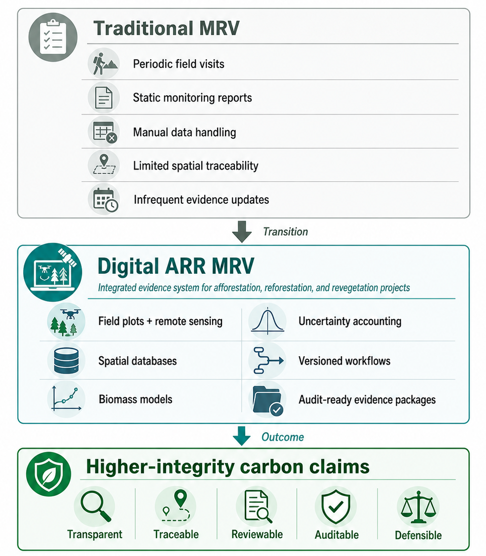
Figure: Traditional MRV vs. digital MRV for ARR projects
The core problem
ARR projects are difficult to monitor accurately because carbon accumulation is not uniform, it is spatial, dynamic and uncertain. Tree growth varies across species, age classes, planting density, soil type, slope, rainfall, disturbance history, grazing pressure, management regime, and farmer behaviour. A plantation block, assisted natural regeneration area, agroforestry mosaic, or revegetated degraded landscape may all qualify as “ARR”, but each has a different carbon response curve and a different monitoring problem.
Because of this variability, credible ARR MRV cannot rely on a single dataset, model, or monitoring method. It needs to work as an integrated evidence system, where each layer addresses a different part of the carbon accounting problem:
Ground plots provide the field-based foundation by measuring tree growth directly, supporting allometric calculations, and validating remote-sensing estimates.
Optical imagery from Landsat and Sentinel-2 enables the tracking of canopy cover, vegetation condition, planting performance, land-cover change, and visible disturbance over time.
Radar data from Sentinel-1 adds monitoring continuity in cloudy regions and can support detection of disturbance patterns and canopy structure proxies.
LiDAR and biomass missions such as GEDI, ESA Biomass, and NISAR strengthen the structural evidence base by improving understanding of canopy height, woody structure, and aboveground biomass.
Finally, reproducible code, open-source workflows, geospatial data, and clear data lineage, make the MRV workflow reviewable and auditable. This is essential when carbon benefit claims need to withstand scrutiny from validators, verifiers, and buyers.

Figure: Five layers of an MRV system
What a robust ARR dMRV architecture could look like
A robust ARR dMRV system needs to be designed as a digital evidence chain. At minimum, a technically defensible system must include the following components:
Project boundary and stratification
The system should maintain clear records of project boundaries, land parcels, management units, planting cohorts, leakage areas, reference regions, and exclusion zones. Where feasible, these should be stored in a spatial database such as PostGIS, with version history, source documentation, and validity dates. This is important because carbon claims are spatial claims. If the boundary, eligible area, or stratification changes, the accounting basis may also change.
Field inventory and ground-truth
Field data remains the foundation of ARR carbon accounting. The system should capture plot coordinates, tree measurements, species, survival, DBH, height, crown condition, management activities, and photo evidence, depending on the project design and methodology. Farmer or landholder identifiers are important where a project involves smallholders, benefit-sharing, or plot-level traceability. A custom mobile application tailored for the project can support this layer.
Biomass modelling
A defensible biomass estimation model should clearly define its response variables, predictors, validation approach, uncertainty method, and applicability domain. Depending on the project context, it may combine field plots, allometric equations, GEDI footprints, radar metrics, optical indices, Landsat time series, topography, rainfall, and stand age. The purpose is to produce a biomass model that is transparent, conservative, and testable.
Uncertainty and conservativeness
Uncertainty should be treated as a core part of the MRV system. Carbon stock and removal estimates should ideally include confidence intervals, error propagation, model diagnostics, and conservative deductions where required by the applicable methodology.
Disturbance and permanence-risk
ARR projects benefit from regular monitoring of risks such as fire, illegal logging, grazing damage, drought stress, pest attack, flood, encroachment, and land-use reversal. Tools like Global Forest Watch, FAO SEPAL, and NASA FIRMS, as well as datasets from Sentinel-2 and Landsat can help detect visible disturbance.
Reporting and audit
A strong dMRV system should be more transparent than a PDF monitoring report. Where feasible, each monitoring period should also produce a structured audit package, including input data records, code version, field data, boundary files, raster files, uncertainty calculations, and QA/QC logs.
The transition from static, document-heavy monitoring toward dynamic, geospatially explicit, and evidence-driven MRV systems should be recognised as critical decision-support and audit infrastructure, in order to strengthen compliance with methodologies, while enabling robust independent validation and verification.

Figure: Satellite sources that can be used for MRV in ARR projects
Implication for developers
For project developers, the key question is whether their MRV system is technically defensible enough to withstand scrutiny from VVBs, buyers, and the skeptical public. A credible ARR project developer should be able to answer questions such as:
Can each claimed removal unit be traced to a project boundary, monitoring period, dataset, and calculation approach?
Can the biomass estimation model be independently reviewed, including its assumptions, and input data?
Are uncertainty deductions transparent and conservative?
Are reversals, underperformance, or land-use changes detected in a timely manner?
Are project claims supported by digitally accessible evidence packages rather than only static PDF reports?
If these questions cannot be answered, projects may still meet the minimum requirements of current methodological standards, however, they have not yet established strong credibility in a market that is rapidly moving toward greater scrutiny, where buyers, regulators, and the broader public increasingly expect carbon claims to be transparent, data-backed, and independently verifiable / auditable.